esri-vorteX-io_partnership

American editor Esri, Esri France and French startup vorteX-io sign a partnership to revolutionize the hydrology sector

Toulouse, France – April 3, 2023 – vorteX-io, an innovative French start-up in the hydrology sector, announced today the signing of a major partnership with Esri, the global leader in location intelligence, as an innovative partner in their program for startups. This partnership will allow vorteX-io to quickly integrate into its value chain the analytical power offered by the ArcGIS software suite, the global reference in geographic information and mapping, into its value chain.

“Our goal is to provide privileged access to hydrological data from Maelstrom® to all ArcGIS users: students, researchers, hydrologists, geomaticians, analysts, urban planners, crisis managers, in other words, to the entire community involved in the study, management, and monitoring of continental and coastal waters” said Guillaume Valladeau, President and co-founder of vorteX-io.

Esri partner network startup logoInitiated by Esri, this three-year partnership program is part of a global initiative by the California-based geomatics editor to help the most promising emerging businesses grow.
The idea is simple: to give winning young companies access to the ArcGIS system, as well as all the resources, services, tools, content, and training they need. Partner startups can thus integrate ArcGIS mapping and location technology both within their business processes and in their products, applications, or platforms, to bring even more added value to their customers.

maelstrom-hydrology-platform-by-vorteX-io

As a reminder, vorteX-io is a French startup whose objective is to become the world leader in hydrological data and services in the next decade.


micro-station_vorteX-io-hydrology
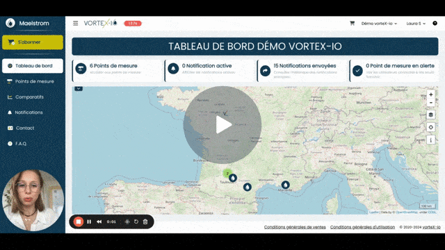
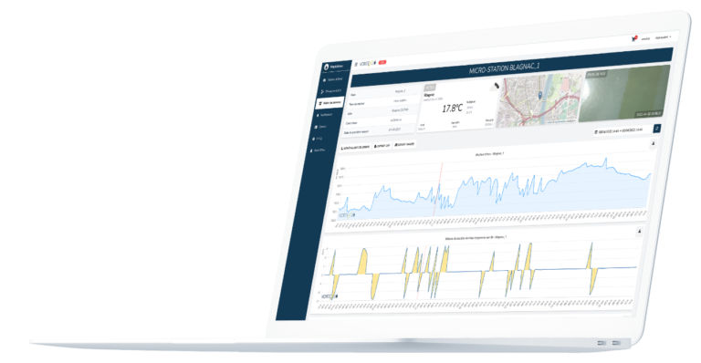
Founded in 2019 by two experts in spatial altimetry, the startup offers services based on two key innovations. On the sensor side, inspired by the space industry, the company has developed its own patented technology of in situ micro-stations for monitoring watercourses. The deployment of this constellation of innovative and communicating sensors above the rivers enables the collection of a very large amount of high-quality hydrological data in real-time. The other innovation, this time related to software, refers to the analysis and dissemination model of hydrological data via a web service accessible by monthly subscription: the Maelstrom® platform.

It is within this platform, unique in the field of hydrology, that ArcGIS technology will soon be integrated by the vorteX-io teams. New advanced features for mapping, spatial analysis, data management, and more will thus quickly be added to those already offered by Maelstrom®.

“The capabilities offered by the ArcGIS system will allow the Maelstrom® platform to be even more efficient in its mission to provide high-quality hydrological data. These contributions will be crucial both for real-time applications and studies requiring historical data.”
Jean-Christophe Poisson, CEO and co-founder, vorteX-io.

The services brought to market by the French hydrology start-up through its platform are helping an increasing number of public and private stakeholders from multiple industries in their operational and strategic decision-making on a daily basis.
For example, Maelstrom® already allows its users to protect people and property by anticipating the occurrence of floods, whether caused by a river or a coastal submersion. The analysis of real-time measurements taken in the field by the micro-stations of the vorteX-io’s network enables the automatic sending of alerts by email, SMS, and Voice Call, in case of risk, giving a precious head start to the platform’s users: local authorities, associations, civil security professionals, industrial companies, etc.

Thanks to this privileged partnership, Maelstrom® users will benefit from the best of GIS technology, powered by Esri, while the ArcGIS community will have access to the best hydrological data offered by vorteX-io.” explains Jean-Paul Gachelin, Director of Strategy at vorteX-io.

By relying on Artificial Intelligence tools and on the database from the network of micro-stations, vorteX-io teams are also developing brand new innovative services. Among them, the digitization of watercourses will allow for the creation of real digital twins as well as powerful predictive algorithms. Ultimately, these developments will enable better understanding, monitoring, and action on watercourses at the scale of entire watersheds. Despite a rapidly changing global climate, it will then be possible to anticipate critical episodes such as floods and droughts, as well as to optimize the management of one of the key resources of this 21st century: Water.

About Esri France

At Esri France, we believe that Geography is essential to enable organizations to design a sustainable future and, more generally, to face the challenges of a world with fragile balances.
Understanding, analysis and making sound decisions are more essential than ever to address the challenges we face in an increasingly complex and interconnected world.
Founded in 1988, Esri France offers innovative solutions to companies and public organizations so that they can take full advantage of a crucial dimension, the geographical dimension that today allows them to respond effectively to their needs while promoting collaboration by reducing organizational silos.
Composed of recognized experts, Esri France teams place clients at the center of their concerns by accompanying them on a daily basis to enhance the geographical dimension and by extension the mapping in all its forms. This is evidenced by its 7 regional locations or by its training centers for new and experienced users. Every year, the company organizes the Esri Francophone Conference, which brings together nearly 6,000 professionals in GIS (Geographical Information Systems). With more than 240 employees, Esri France is the leading French provider of GIS, by virtue of its number of customers, turnover and innovation capacity. Its strength also lies in its network of specialized, close and competent partners on which it relies. Esri France works closely with Esri, the pioneer and world leader in Geographical Information Systems.
Visit us at esrifrance.fr

About vorteX-io

vorteX-io is a French innovative technology company in the hydrology sector. The start-up’s offer is based on the unique combination of two key innovations: an autonomous remote sensing sensor based on space technologies -the vorteX-io micro-station- and a web platform offering a range of associated hydrological services. The company is deploying in Europe and beyond its constellation of micro-stations dedicated to real-time monitoring of waterways. The data collected is transmitted, analyzed, stored in real time and then disseminated via a web service accessible by monthly subscription, the Maelstrom® platform. The services marketed allow to know at any time the state of the watercourses at the scale of catchment areas. Its users can also receive personalized alerts to anticipate floods, droughts and optimally manage one of the major challenges of the XXIᵉ century: water resources.
To know more about it: vortex-io.fr/en/

Resources

END

The vorteX-io Newsletter

Follow the latest news from vorteX-io:
projects & innovations, updates of the Maelstrom® platform, in-depth articles on hydrology...

I subscribe
Also read

Première visite ?

Il existe plusieurs types de plans d’abonnement pour accéder à la plateforme MAELSTROM®

Accédez à MAELSTROM®

vortex-io-solution-monitoring-course-of-water

Vous avez déjà un compte sur MAELSTROM® ou vous souhaitez en créer un

First visit?

There are several types of subscription plans to access the MAELSTROM® platform

Access MAELSTROM®.

vortex-io-solution-monitoring-course-of-water

You already have an account on MAELSTROM® or you want to create one