Use case
Preserving aquatic environments
VorteX-io transforms hydrological monitoring to support you in your missions to monitor and protect aquatic ecosystems.

Key features
Data for aquatic biodiversity
Based on continuous, multi-parameter, in-situ measurements, vorteX-io lets you monitor, compare and analyze the evolution of your watercourses, today and over the long term.


Monitoring river conditions
VorteX-io provides you with the parameters you need to preserve aquatic ecosystems:
- Surface temperature
- Water height, surface velocity, flow rate
- Air temperature
- Cumulative precipitation
Advanced comparisons
Observe and compare the hydrological dynamics of your watercourses over time and at different key points
- Comparison of parameters at several stations
- Monitoring progress over time
- Support for different networks (vorteX-io, state networks, your sensors)


Instant notifications
- Customizable alert thresholds for flow, height, surface temperature
- Instant alert notifications by SMS, e-mail or voice call
Our customers
At your side to preserve aquatic ecosystems
A shared commitment to preserving aquatic ecosystems.
Demonstration
Create your free account and explore vorteX-io
Test our services today and discover what vorteX-io can do for you (no credit card required).
Monitor the health of your waterways
vorteX-io improves the efficiency of your business through automated, centralized data collection.
Detect environmental pressures and alterations
Monitor hydrological flows in wetlands and aquatic habitats
Keep an eye on the impact of industrial, agricultural and urban waste
Determine the consequences of major climatic events
Track the impact of your actions over time
Analyze short-, medium- and long-term trends
Monitor parameters upstream and downstream of sensitive areas
Concretely measure the effectiveness and reach of your actions to adjust your strategies
Respond to environmental threats
Anticipate the main risks (algal blooms, eutrophication, etc.)
Optimize your time and budget with automated data collection and centralization
All-in-one service
To manage, you need to know.
To know, you need to measure.
In-depth knowledge of your waterways relies on precise, continuous monitoring.
1. Collecting measurements
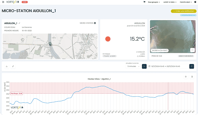
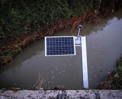
Thanks to a range of on-board sensors, our solar-powered stations continuously record water level, surface speed, temperature and other key parameters.
2. Transmission and analysis
Measurements are transmitted by 3G/4G to our secure servers, processed by advanced algorithms and available in just a few minutes on vorteX-io.
3. Visualization and comparison
Access your data in real time with your usual web browser.
4. Your decision-support services
Identify trends, anticipate risks and adjust your operational response.
FAQs
Find the most frequently asked questions about vorteX-io and the preservation of aquatic environments.
Contact usOur surface temperature sensors offer an accuracy of ±1°C and allow data to be updated up to 4 times an hour.
The stations are mounted on existing structures (bridges, footbridges) and operate autonomously using a solar panel and an internal battery. Maintenance and software updates are carried out remotely, and equipment can be replaced within a few days in the event of failure.
Data is accessible in real time via the vorteX-io platform. They can be visualized as graphs, exported as CSV files or integrated into other systems via API.
Yes, you can customize the way you receive notifications (by e-mail, SMS, voice call) and the thresholds that trigger these alerts.
The LiDAR sensors on vorteX-io stations measure the height of water masses to the nearest centimeter.
Try vorteX-io free of charge
Monitor, anticipate and protect aquatic environments with state-of-the-art technology.