Your hydrological sentinel
Whether you’re an operator, manager, scientist or decision-maker, observe and analyze watercourses in real time.
Our customers
Performance builds trust
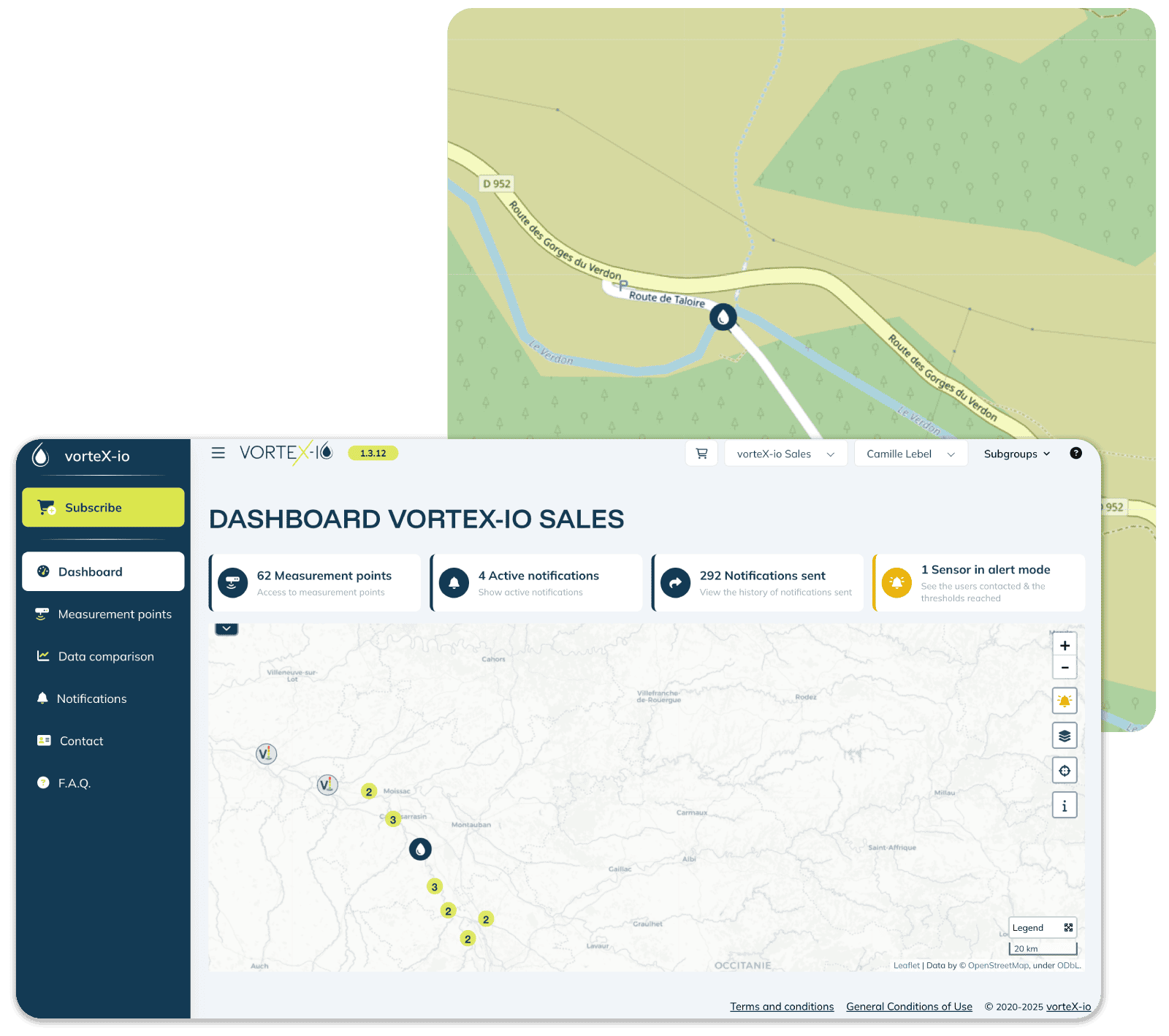
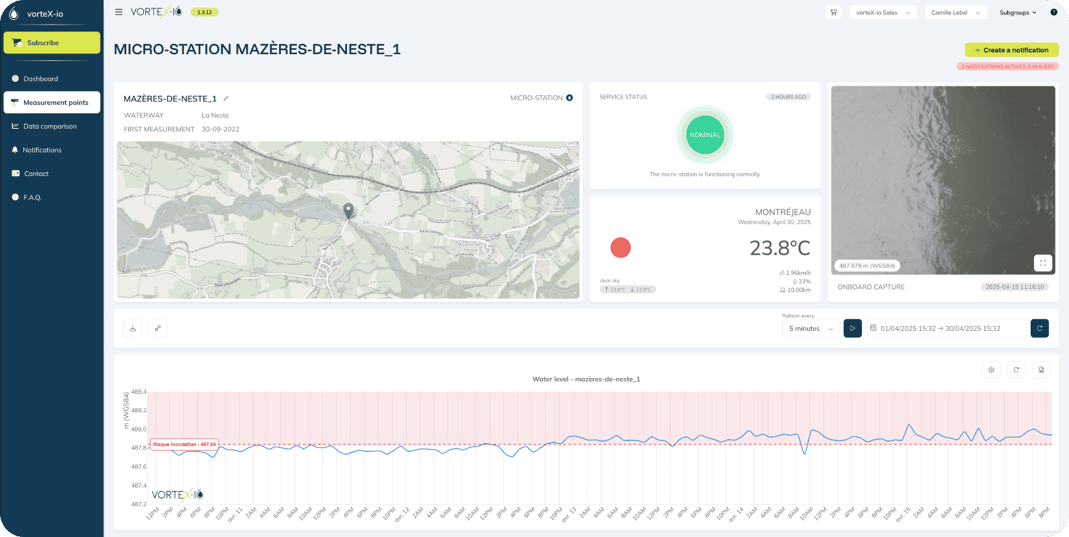
Track river evolution
The platform provides a range of cutting-edge hydrological services. With this decision-making tool, you always stay one step ahead of river conditions.
Continuous data collection
Data is updated hourly by default, with faster updates in case of flood risk.
Smart post-processing
Our algorithms verify data consistency.
Instant alerts
Email, SMS, and voice call alerts when thresholds are exceeded.
Measurement comparison
Easily compare readings at various points along the same river.
Multi-parameter measurements
Water level, surface velocity, surface temperature, flow rate.
Automated reports
Detailed event reports are generated automatically.
External data integration
We integrate public data for a comprehensive view of the region’s water situation.
Key figures
Next-gen water management software
vorteX-io services rely on two strengths: a dense in situ network and data availability in less than 15 minutes.
+350
stations deployed, + 1000 by 2025
97.5%
of data received
in under 15
Free platform trial
Create your account for free and test vorteX-io services with our demo stations.
How does it work?
Our 4-step offer
To manage, you need to know.
To know, you need to measure.
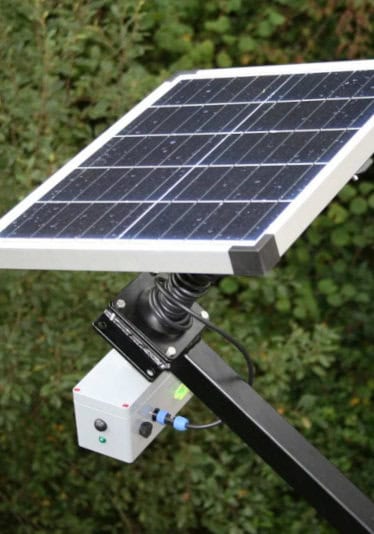
1. Data collection
Our stations are equipped with several sensors: LiDAR, camera, thermal sensor, GNSS system, and accelerometer for multi-parameter measurement.
2. Transmission & processing
Data is transmitted via 3G/4G to our secure servers and is available within minutes on vorteX-io.
3. Data visualization
Centralized, processed, and standardized, this data constantly feeds our platform for innovative hydrological services.
4. Your decision-support services
You can consult, compare, analyze, and even receive notifications to drive your decisions.
Benefits
You pay for the service, we handle the equipment
Energy autonomous
vorteX-io stations are fully energy autonomous thanks to their solar panel and onboard battery.
Quick installation
Installation by our rope access partners takes just 1 hour.
Continuous collection
In case of network outage, the station stores data locally and transmits as soon as the connection is restored.
Rugged
The station has been robustly tested for durability in extreme environmental conditions.
Preventive maintenance
Enjoy unmatched service continuity thanks to digital monitoring of the station fleet.
Yes, as an online platform, vorteX-io can be accessed from any internet-connected device—computer, tablet, or smartphone.
Data is updated in real time. By default, the acquisition rate is one measurement per hour. However, if conditions require, each micro-station can switch to intensive mode and record every 15 minutes.
Yes, our data can be exported in CSV format, compatible with most data analysis, modeling, and GIS software. An API is also available for more advanced and automated integration into your existing systems.
Want to test our service?
Whether you’re a local authority, a company, a transport network or an insurance organization, find out how vorteX-io helps you monitor, anticipate and act.
